Winston-ClassB
Senior Member
When we first discovered ‘ground-based’ travel in the fall of 2012 (i.e. driving), we coincidentally stumbled onto the practice of recording and plotting detailed track files of our travels. We had no idea how useful and rewarding this practice would become. It’s fascinating to reflect on past travels if, for no other reason, to reminisce. But beyond these simple looks into the past, we were surprised how often we have relied on this data to confirm details of where we’ve been, what we’ve done - - maybe to share with others or, more selfishly, to relive: “Do you remember that neat place . . . where was it? Let’s go back.” We’ve even used this record to flush-out small details like where, precisely, along the West coastal highway, did we ‘pull-off’ to take those gorgeous, but non-geotagged, photos!
It is not the purpose of this thread ‘to sell’ our system. In many respects ours is old, clumsy and arcane and could be difficult to recreate even if desired. Rather, we seek to plant a few ideas that others can modify and extend to more modern or alternative hardware and software. And, further, we know that many on this forum have already developed their own approaches. Please use this thread to share your solutions.
We’re gadget freaks, into technology and the internet. So we started with our Windows Surface Pro tablet computer “Ram-mounted” between driver and passenger seats:

We’re pretty much connected 24/7 to the internet but, alas, ours is not an internet or cloud based system. Ours is self-contained. And, yes, a laptop or tablet is required - - but not real-time. You don’t have to go to the extreme of ‘planting’ your computer in front of the dash as we did.
We start with a Garmin handheld GPS receiver of the following type (an eTrex H30) just sitting on the dash:
 .
.
In the simplest implementation, the GPS is tied to nothing, just sits on the dash and runs for two driving days on a pair of alkaline AA cells. Some have suggested that a cell phone can do the same thing - - but we have found the Garmin to be more reliable for several reasons. First, it has a better, more sensitive receiver - - it virtually never loses signal sitting on the dash - - our cell phone occasionally does. And it’s always there, on and in the correct spot. Too often we’ve found our cell phone moved, or the batteries dead, or some other, unexpected malady that interrupts the continuity of the recorded track. The Garmin is a firmwear driven solution that’s nearly foolproof.
While optional, we have chosen to interconnect our dash-located Garmin with the Ram-mounted Surface tablet through USB. We do this for two reasons. First, we don’t have to worry about batteries for the Garmin - - it’s powered through the Surface tablet and, second, it allows us to use the Garmin’s satellite data real-time for ‘programs’/apps on the Surface. Again, this interconnection is not required real-time - - we do it because it adds additional capability and can be so easily implemented in view of where our Surface is normally located. What is required, though, is downloading the Garmin files every few days (depending on the model, the Garmin has limited track file memory and will start over-writing earlier track files when it runs out of file space).
We save each days track files. We combine each days track files to create “Trip Files” and save those, too, separately. Indeed, we add each days track file to the current Trip File so, at the end of each day, we can see our total trip from Day 1 to the ‘then’ present.
Our solution becomes slightly technical at this point. One must be familiar with ‘file types’ and be able to do some ‘manipulation’. For example, the Garmin most easily outputs .GPX files. Here’s a typical single ‘record’/datapoint from the Garmin:
“Trackpoint N43 37.358 W86 32.223 11/5/2019 6:56:06 AM 761 ft 111 ft 0:49:08
0.0 mph 42ø true”
Lots of interesting information - - but unnecessary for simple track plotting. By the time we’ve ‘manipulated’ the Garmin .GPX files, that same datapoint will look like this:
“43.622633,-86.53705"
A simple decimal-degrees, latitude and longitude number.
But let’s return from the technical to the simple. So far, all we’ve done is drive around for a day with the Garmin sitting on the dash. We’re now relaxing with a glass of wine and some crackers by our campfire, tablet on our lap - - we download the Garmin file and plot it on our tablet. More specifically, after making those ‘technical manipulations’, we plot it on our DeLorme Topo 10 Mapping software. Voila, done.
But here’s where we’re hoping some of you have advanced. DeLorme was bought by Garmin and Garmin all but dumped the DeLorme computer program line . . . thus, one can’t officially buy DeLorme’s Topo 10 software. And even if you can, it’s not being maintained. Unlike the web-based Google solution, DeLorme’s maps are more than a decade old. Yes, the country hasn’t changed size and the rivers and mountains haven’t moved. But it would be nice to have all those detailed track files plotted on actual roads.
We’re hoping that someone on the forum has found a ‘piece of Windows software’ that is ‘current’ and can replace DeLorme Topo 10. Or maybe we have to change platforms? To Apple or Android? Or, at the least, maybe there’s a Forum member who is more facile with Google Maps and can perform a new ‘manipulation’ to place outside (non-Google) data onto the Google Map?
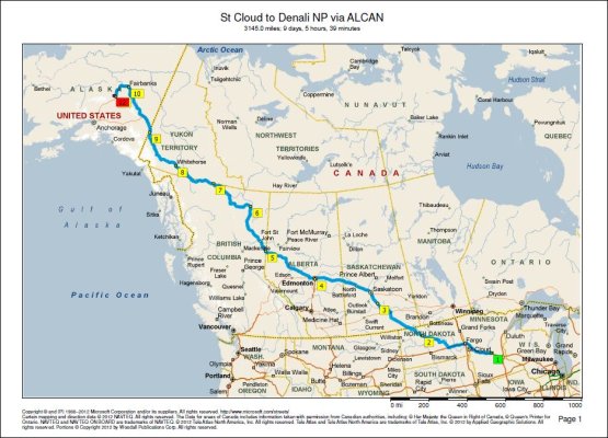
But, for now, let’s look at how our Garmin data can be used on our Windows DeLorme Topo 10 map program.
Ahh, yes, such great memories - - our first camping trip (tent back then):

And the beginning of our maiden DIY ProMaster life:

That ultimately led us to ‘take a wrong turn’ and end up here:

And maybe it’s fitting to show our last camping trip:

Observing all the ‘failures’ of this “Last” Camping Trip, one might ponder whether this will be our Final/Last Trip? But we don’t think so. Let spring arrive and we’ll be off again. (Suffice to say it was exciting to have 30 seconds advance notice of a total transmission failure on the Construction/Interstate in Indianapolis followed within hours after transmission replacement, with a double failure that resulted in overchanging of our lithium pack - - these latter failures will be reported in this Forum, later, when the details and consequences have been determined.)
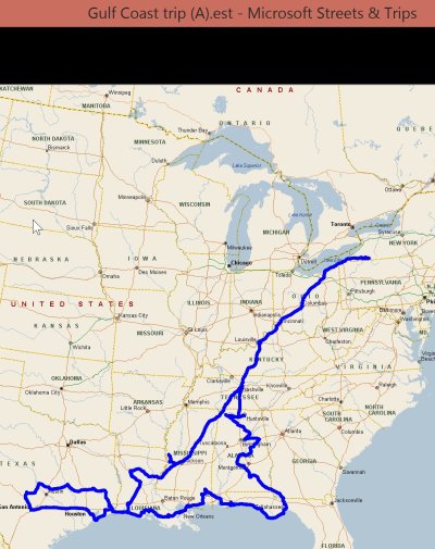
Here’s another “Trip” plot:

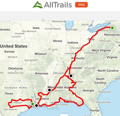
One of our more wacko travel objectives has been to find a GeoCache in every county of this country. The above map shows our spring 2018 wonderings through Texas in pursuit of 208 of Texas’ 254 counties.
We got carried away “with the West” in 2013 so we’ve used ‘color’ to distinguish two nearly overlapping trips:

What’s nice about the Garmin-based track file is its detail. Here is a view of our travels around Crater Lake - - notice you can see not only every ‘switchback’, but our travels through the campground, including to two ‘loops’ we camped in:
 .
.
We’ll conclude our somewhat misdirected ‘Travelog Map Slideshow’ with this overall composite:
 .
.
Hopefully, while extensive, the above series of maps demonstrates how flexible the concept of trip mapping can be and how much fun one can have with massaging the collected track files to create a myriad of travel stories.
We look forward to hearing how others have documented their travels.
It is not the purpose of this thread ‘to sell’ our system. In many respects ours is old, clumsy and arcane and could be difficult to recreate even if desired. Rather, we seek to plant a few ideas that others can modify and extend to more modern or alternative hardware and software. And, further, we know that many on this forum have already developed their own approaches. Please use this thread to share your solutions.
We’re gadget freaks, into technology and the internet. So we started with our Windows Surface Pro tablet computer “Ram-mounted” between driver and passenger seats:
We’re pretty much connected 24/7 to the internet but, alas, ours is not an internet or cloud based system. Ours is self-contained. And, yes, a laptop or tablet is required - - but not real-time. You don’t have to go to the extreme of ‘planting’ your computer in front of the dash as we did.
We start with a Garmin handheld GPS receiver of the following type (an eTrex H30) just sitting on the dash:
In the simplest implementation, the GPS is tied to nothing, just sits on the dash and runs for two driving days on a pair of alkaline AA cells. Some have suggested that a cell phone can do the same thing - - but we have found the Garmin to be more reliable for several reasons. First, it has a better, more sensitive receiver - - it virtually never loses signal sitting on the dash - - our cell phone occasionally does. And it’s always there, on and in the correct spot. Too often we’ve found our cell phone moved, or the batteries dead, or some other, unexpected malady that interrupts the continuity of the recorded track. The Garmin is a firmwear driven solution that’s nearly foolproof.
While optional, we have chosen to interconnect our dash-located Garmin with the Ram-mounted Surface tablet through USB. We do this for two reasons. First, we don’t have to worry about batteries for the Garmin - - it’s powered through the Surface tablet and, second, it allows us to use the Garmin’s satellite data real-time for ‘programs’/apps on the Surface. Again, this interconnection is not required real-time - - we do it because it adds additional capability and can be so easily implemented in view of where our Surface is normally located. What is required, though, is downloading the Garmin files every few days (depending on the model, the Garmin has limited track file memory and will start over-writing earlier track files when it runs out of file space).
We save each days track files. We combine each days track files to create “Trip Files” and save those, too, separately. Indeed, we add each days track file to the current Trip File so, at the end of each day, we can see our total trip from Day 1 to the ‘then’ present.
Our solution becomes slightly technical at this point. One must be familiar with ‘file types’ and be able to do some ‘manipulation’. For example, the Garmin most easily outputs .GPX files. Here’s a typical single ‘record’/datapoint from the Garmin:
“Trackpoint N43 37.358 W86 32.223 11/5/2019 6:56:06 AM 761 ft 111 ft 0:49:08
0.0 mph 42ø true”
Lots of interesting information - - but unnecessary for simple track plotting. By the time we’ve ‘manipulated’ the Garmin .GPX files, that same datapoint will look like this:
“43.622633,-86.53705"
A simple decimal-degrees, latitude and longitude number.
But let’s return from the technical to the simple. So far, all we’ve done is drive around for a day with the Garmin sitting on the dash. We’re now relaxing with a glass of wine and some crackers by our campfire, tablet on our lap - - we download the Garmin file and plot it on our tablet. More specifically, after making those ‘technical manipulations’, we plot it on our DeLorme Topo 10 Mapping software. Voila, done.
But here’s where we’re hoping some of you have advanced. DeLorme was bought by Garmin and Garmin all but dumped the DeLorme computer program line . . . thus, one can’t officially buy DeLorme’s Topo 10 software. And even if you can, it’s not being maintained. Unlike the web-based Google solution, DeLorme’s maps are more than a decade old. Yes, the country hasn’t changed size and the rivers and mountains haven’t moved. But it would be nice to have all those detailed track files plotted on actual roads.
We’re hoping that someone on the forum has found a ‘piece of Windows software’ that is ‘current’ and can replace DeLorme Topo 10. Or maybe we have to change platforms? To Apple or Android? Or, at the least, maybe there’s a Forum member who is more facile with Google Maps and can perform a new ‘manipulation’ to place outside (non-Google) data onto the Google Map?
But, for now, let’s look at how our Garmin data can be used on our Windows DeLorme Topo 10 map program.
Ahh, yes, such great memories - - our first camping trip (tent back then):
And the beginning of our maiden DIY ProMaster life:
That ultimately led us to ‘take a wrong turn’ and end up here:
And maybe it’s fitting to show our last camping trip:
Observing all the ‘failures’ of this “Last” Camping Trip, one might ponder whether this will be our Final/Last Trip? But we don’t think so. Let spring arrive and we’ll be off again. (Suffice to say it was exciting to have 30 seconds advance notice of a total transmission failure on the Construction/Interstate in Indianapolis followed within hours after transmission replacement, with a double failure that resulted in overchanging of our lithium pack - - these latter failures will be reported in this Forum, later, when the details and consequences have been determined.)
Here’s another “Trip” plot:
One of our more wacko travel objectives has been to find a GeoCache in every county of this country. The above map shows our spring 2018 wonderings through Texas in pursuit of 208 of Texas’ 254 counties.
We got carried away “with the West” in 2013 so we’ve used ‘color’ to distinguish two nearly overlapping trips:
What’s nice about the Garmin-based track file is its detail. Here is a view of our travels around Crater Lake - - notice you can see not only every ‘switchback’, but our travels through the campground, including to two ‘loops’ we camped in:
We’ll conclude our somewhat misdirected ‘Travelog Map Slideshow’ with this overall composite:
Hopefully, while extensive, the above series of maps demonstrates how flexible the concept of trip mapping can be and how much fun one can have with massaging the collected track files to create a myriad of travel stories.
We look forward to hearing how others have documented their travels.
Last edited: